

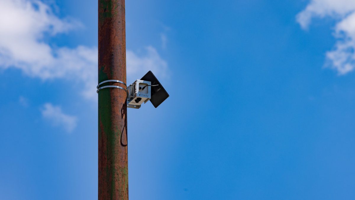
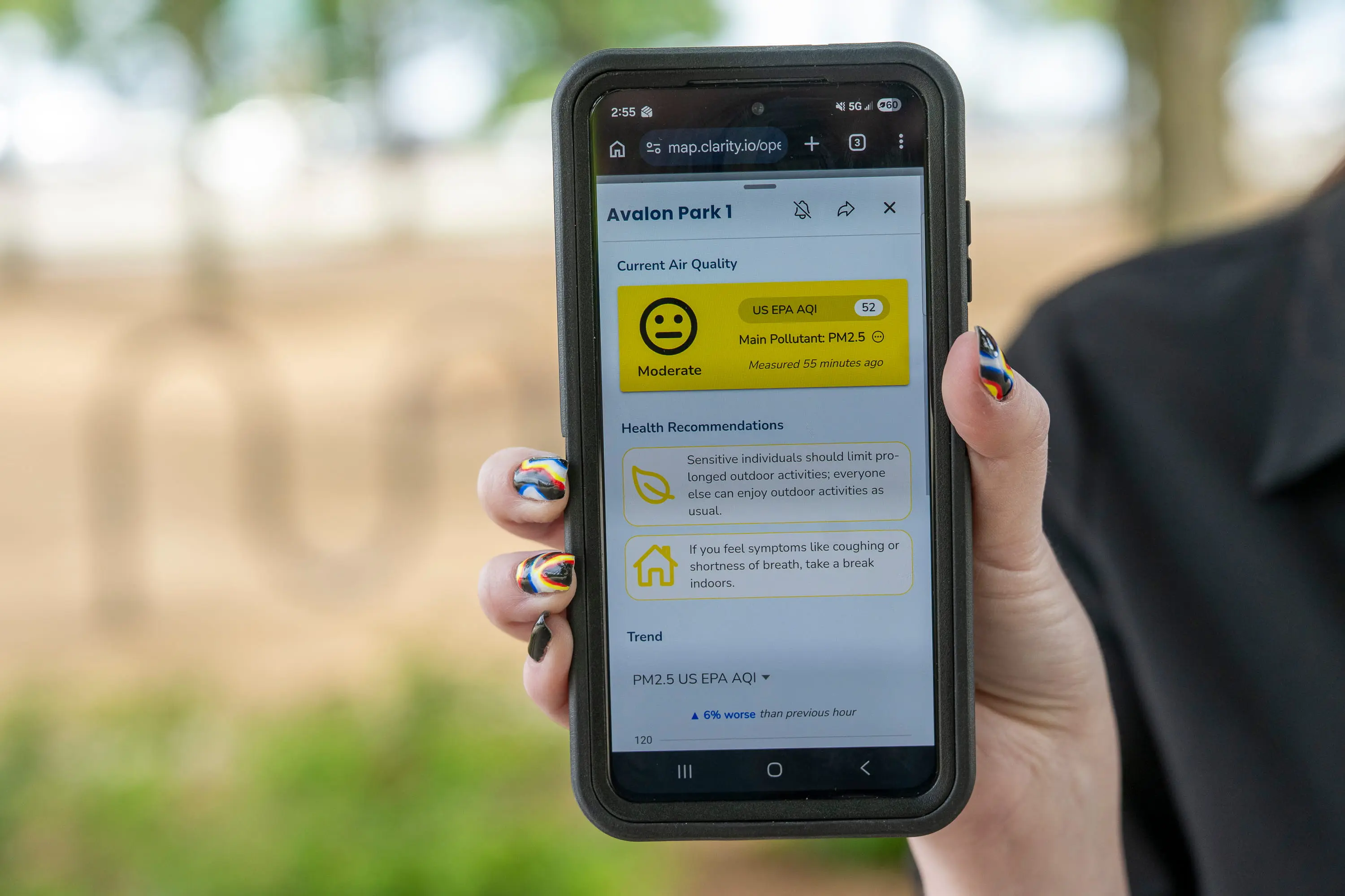
Standing amidst the lush greenery of Chicago’s Grant Park, Serap Erdal, a professor of environmental and occupational health sciences at the University of Illinois Chicago, recently paused at a nondescript light pole to consult her smartphone. Above her, a small, silver, solar-powered device—no larger than a standard tissue box—hummed silently, capturing the invisible chemical makeup of the city’s atmosphere. As the midday sun glinted off the glass facades of the surrounding Loop skyscrapers, Erdal observed a bright green dot on her screen. The Air Quality Index (AQI) at this specific GPS coordinate was 31, a level the Environmental Protection Agency (EPA) classifies as "Good," indicating minimal risk to the general public.
This single data point is part of a revolutionary initiative known as Open Air Chicago. With 277 monitors strategically placed across every ward and community area, the project represents the largest community-based air quality monitoring network in the United States. While the breeze off Lake Michigan kept the downtown air clear on this particular afternoon, the map on Erdal’s phone told a different story for the city’s far South Side. There, in neighborhoods historically burdened by heavy industry and freight corridors, the monitors flickered with different colors, signaling a disparity in air quality that has long been a point of contention for local activists.
The Genesis of Open Air Chicago: A Battle for Environmental Justice
The establishment of this massive monitoring network was not merely a scientific endeavor; it was the hard-won result of a protracted legal and social struggle. The origins of Open Air Chicago can be traced back to a high-profile controversy involving the relocation of General Iron, a scrap-metal shredding operation. For decades, the facility operated in Lincoln Park, a predominantly wealthy and white neighborhood on the city’s North Side. When the company sought to move its operations to the Southeast Side—a region already saturated with industrial legacy and home to a majority Black and Latino population—the community rose in defiance.
In 2021, local environmental advocacy groups, including the Southeast Environmental Task Force, filed a landmark civil rights complaint with the U.S. Department of Housing and Urban Development (HUD). The complaint alleged that the city’s role in facilitating the move constituted a violation of the Fair Housing Act, arguing that the relocation intentionally shifted environmental hazards from a privileged neighborhood to an already overburdened community of color.
The ensuing legal battle culminated in a 2023 settlement between the City of Chicago and the community organizations. A central pillar of this agreement was the commitment to launch a comprehensive, hyperlocal air monitoring network. Funded by a $4 million investment, the partnership between the City of Chicago and the University of Illinois Chicago (UIC) ensures that the network will remain operational through at least the beginning of 2030. For residents of the South and West Sides, the project provides more than just data; it provides a defense against what many describe as "environmental gaslighting."

Technical Specifications: Measuring the Invisible Killers
The Open Air Chicago network utilizes low-cost, solar-powered sensors designed to detect two primary pollutants: nitrogen dioxide (NO2) and fine particulate matter (PM2.5). While these devices are less expensive than the "gold standard" regulatory-grade monitors used by the EPA, their strength lies in their density. By placing sensors less than a mile apart, the network captures over 20,000 data points daily, allowing researchers to see how pollution levels fluctuate from one street corner to the next.
PM2.5 is of particular concern to public health officials. These microscopic particles, roughly one-twentieth the width of a human hair, are small enough to bypass the body’s natural defenses, traveling deep into the lungs and entering the bloodstream. Chronic exposure to PM2.5 is a leading environmental factor in premature mortality, linked to a host of respiratory and cardiovascular diseases, including childhood asthma, heart attacks, and strokes. Nitrogen dioxide, primarily a byproduct of fossil fuel combustion from vehicles and industrial boilers, further exacerbates respiratory conditions and contributes to the formation of ground-level ozone.
In Chicago, the health implications of these pollutants are starkly divided along geographic lines. According to the Chicago Health Atlas, neighborhoods on the South and West Sides experience significantly higher rates of emergency room visits for asthma compared to their North Side counterparts. Until now, these communities lacked the granular, time-stamped data necessary to prove the direct link between local industrial emissions and their specific health outcomes.
The Summer Smog and the Wildfire Factor
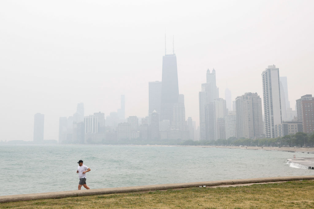
The launch of the network comes at a critical time as Chicago enters its peak pollution season. During the summer months, intense sunlight and high temperatures act as a catalyst for chemical reactions between volatile organic compounds and nitrogen oxides. This process creates ground-level ozone—the primary component of smog. As climate change continues to drive record-breaking temperatures across the Midwest, the "smog season" is becoming longer and more severe.
Adding to the complexity is the increasing frequency of transboundary pollution from wildfires. In June 2023, smoke from historic Canadian wildfires descended upon the Midwest, turning Chicago’s skies a dystopian orange and pushing air quality into the "Unhealthy" and "Very Unhealthy" categories. A study published in early 2024 revealed that this smoke raised ground-level ozone in Chicago by nearly 10% of the federal limit.
The impact of these wildfires is effectively erasing decades of progress made under the Clean Air Act. Research published in the journal Science earlier this month indicates that while federal regulations successfully reduced ozone-forming gases by 11% between 2003 and 2015, the surge in wildfire activity since 2015 has undone approximately one-third of those gains. This trend is estimated to cause an additional 318 premature deaths annually across the United States due to wildfire-related ozone exposure.

Integrating Ground Data with Satellite Observations
The Open Air Chicago network fills a critical gap in existing atmospheric monitoring. While NASA satellites provide a global view of air pollution, they often struggle to distinguish between pollutants high in the atmosphere and those at the "breathing zone" near the Earth’s surface.
Carl Malings, an assistant research scientist at Morgan State University and NASA’s Goddard Space Flight Center, notes that satellite data can sometimes be misleading without ground-level verification. A smoke plume detected from space might be passing high overhead without affecting the air quality on the ground. Conversely, localized industrial emissions might be too small for a satellite to resolve but pose a significant risk to people living nearby. By combining the 277 ground sensors with satellite imagery, Chicago is creating a three-dimensional understanding of its air quality landscape.
A Timeline of the Open Air Chicago Initiative
- 2020-2021: The City of Chicago announces plans to permit the relocation of General Iron to the Southeast Side, sparking massive community protests and hunger strikes.
- May 2021: Environmental groups file a Title VI civil rights complaint with HUD, alleging environmental racism in the city’s zoning and permitting processes.
- February 2022: Under pressure from the federal government, the Chicago Department of Public Health denies the final permit for the scrap-metal facility.
- May 2023: The City of Chicago enters into a formal settlement agreement with HUD and community groups, pledging to overhaul its environmental policies and launch a monitoring network.
- September 2023: The Open Air Chicago project officially goes live, with the first wave of 277 monitors installed across the city’s 50 wards.
- June 2024: The network faces its first full summer season, providing real-time data during periods of extreme heat and potential wildfire smoke events.
- 2024-2029: The five-year data collection phase continues, with UIC researchers analyzing trends to inform future urban planning and public health interventions.
Implications for Future Policy and Urban Planning
The data generated by Open Air Chicago is expected to serve as a blueprint for municipal governance. For decades, urban planning in major American cities has been reactive rather than proactive regarding environmental health. With a clear record of where pollution hotspots exist, city officials can no longer plead ignorance when making decisions about where to site new warehouses, distribution centers, or industrial plants.
Oscar Sanchez, director of the Southeast Environmental Task Force, views the network as a tool for empowerment. "This is about ensuring that there’s publicly available information so people are not gaslit about their experience," Sanchez said. The transparency of the data allows residents to advocate for themselves, using hard evidence to demand stricter enforcement of environmental regulations or the implementation of "green buffers" in their neighborhoods.
Furthermore, the project has implications for the transition to electric vehicles. Professor Erdal has previously studied how the electrification of city buses and delivery fleets could disproportionately benefit Latino and Black neighborhoods that currently bear the brunt of diesel exhaust. The Open Air Chicago sensors will provide the baseline data needed to measure the effectiveness of these green initiatives as they are rolled out.
As the program progresses toward its 2029 milestone, there are already calls to expand its scope. Researchers hope to eventually incorporate sensors for additional pollutants, such as sulfur dioxide and lead, and to integrate the network with school-based health programs. For now, the 277 silver boxes scattered across Chicago stand as a testament to a community that refused to be ignored, turning a local conflict into a national model for environmental transparency and public health protection. In a world where the climate is rapidly changing and the air we breathe is increasingly under threat, Chicago’s "open air" approach may be the most vital infrastructure project the city has ever undertaken.
