
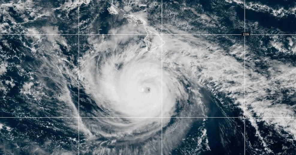
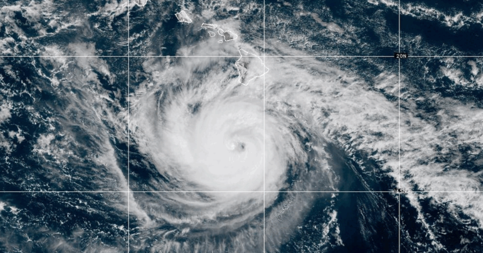
Hurricane Nolo continues to churn through the Pacific Ocean, rapidly approaching the threshold of a Category 5 storm as it tracks away from the main Hawaiian Islands. As of early Monday morning, the National Hurricane Center (NHC) reported that the system is packing maximum sustained winds of 155 mph, placing it just 2 mph shy of the highest classification on the Saffir-Simpson Hurricane Wind Scale. While the storm’s path keeps its eye well south and southwest of the state’s population centers, the sheer scale of the hurricane presents a multifaceted threat to Hawaii’s ecosystems, infrastructure, and coastal stability.
The Current Meteorological Situation
Meteorologists are closely monitoring the storm’s trajectory as it moves toward the Papahanaumokuakea Marine National Monument. This vast, 582,000-square-mile protected area represents one of the largest conservation zones in the world, and its remote ecosystem is particularly vulnerable to the extreme oceanic agitation caused by a system of Nolo’s magnitude.
At the start of the week, the hurricane’s wind field remained expansive. Hurricane-force winds extend outward up to 35 miles from the storm’s center, while tropical storm-force winds reach an even more significant radius of 150 miles. This breadth ensures that even as the storm center moves away from the inhabited islands, the secondary effects of the system—such as high-frequency swells and storm surge—will remain a primary concern for local authorities.
Chronology of a High-Stakes Emergency
The development of Hurricane Nolo follows a tense period of preparation for the State of Hawaii. On Friday, September 26, the potential severity of the storm prompted federal intervention. President Trump officially approved an emergency declaration for the state, a move designed to unlock federal resources, funding, and logistical support for recovery and mitigation efforts.
Governor Josh Green, in coordination with the Federal Emergency Management Agency (FEMA), has been managing the state’s posture as the storm tracks northwest. The decision to close all state parks on the Big Island and Maui was made early to prevent casualties in areas prone to flash flooding and dangerous surf. The state’s emergency management apparatus shifted into high gear last week, anticipating that even if the eye of the storm avoids a direct hit on the main islands, the peripheral moisture could prove disastrous.
Precipitation and Coastal Hazards
The primary threat to the Hawaiian Islands, particularly the Big Island and Maui, remains the significant volume of rainfall expected as the storm passes. Forecasters have issued warnings for the eastern and southern portions of the Big Island, where up to 20 inches of rain could accumulate. Such heavy saturation in Hawaii’s steep, volcanic terrain is a precursor to mudslides and localized flooding, which can paralyze transportation networks and isolate rural communities.
Maui is expected to receive between 4 and 8 inches of rain, while the remaining islands are projected to see between 1 and 5 inches. Beyond the rainfall, the NHC has placed a high priority on the "life-threatening surf" and rip current conditions affecting south-facing shores. These swells, generated by the massive energy of the hurricane, are expected to persist for several days, complicating maritime navigation and coastal access.
A Season of Unprecedented Pacific Activity
The arrival of Hurricane Nolo is not an isolated event; it is part of a remarkably active and volatile Pacific hurricane season that has tested the resilience of the Hawaiian Islands repeatedly. Climate scientists have noted that the central Pacific has seen an increase in both the frequency and intensity of tropical cyclones, often linked to shifting sea surface temperatures.
Earlier this month, Hurricane Lowell made landfall in the western Hawaiian islands of Kauai and Niihau. The damage was extensive, with the storm’s high winds downing power lines, destroying mature trees, and causing significant road damage that took weeks to stabilize. Before that, the region was reeling from the impact of Hurricane Lala, which occurred last month. That storm was particularly devastating, resulting in the destruction of approximately 100 homes and triggering a series of massive landslides that forced the evacuation of dozens of families.
The coincidence of Hurricane Nolo occurring simultaneously with Hurricane Polo, which is currently churning off the southwestern coast of Mexico, highlights the high-energy state of the Pacific basin. This "dual-storm" environment often complicates weather modeling, as the interaction between these massive atmospheric systems can sometimes influence their tracks in unpredictable ways.
Socio-Economic and Infrastructure Implications
The recurring nature of these storms in 2026 has raised difficult questions regarding long-term infrastructure planning. Hawaii’s geography, defined by its isolation and reliance on limited road networks and single-point power distribution, makes it uniquely susceptible to prolonged outages during extreme weather events.
Economically, the repeated closure of state parks and the warnings to avoid coastal areas have a cascading effect on the tourism industry, which remains a pillar of the Hawaiian economy. Furthermore, the agricultural sector on the Big Island faces potential ruin if the 20-inch rainfall projections materialize, as crops and livestock operations in low-lying areas lack the drainage infrastructure to handle such an influx of water.
From a policy perspective, the emergency declaration signed by the President is expected to cover a wide array of costs, including debris removal, emergency protective measures, and permanent repairs to public facilities. However, officials warn that federal funding is a secondary defense to personal preparedness. "The federal government provides the safety net, but residents must be the first line of defense," noted a representative from the Hawaii Emergency Management Agency.
Analytical Perspective on Storm Trends
Meteorological data from the past decade suggests that storms in the central Pacific are trending toward higher peak intensities before they reach the higher latitudes where they typically dissipate. This "intensification near the islands" phenomenon is a growing concern for disaster management agencies. Unlike the Atlantic, where storms have a long runway to lose strength over cooler waters, Hawaiian storms often maintain their integrity right up to the doorstep of the archipelago.
The reliance on the Saffir-Simpson scale to communicate these risks to the public is also being re-evaluated by some in the scientific community. While Nolo is technically a Category 4, the distinction between it and a Category 5 is often negligible in terms of the damage potential when a storm is this large. The wind speed, while a critical metric, does not fully capture the threat posed by storm surge and the total rainfall capacity of a system this size.
Looking Ahead: The Recovery Phase
As Nolo continues its path toward the northwest, the focus of the National Hurricane Center and local authorities will shift from monitoring the storm’s intensity to assessing the aftermath of the rainfall. Recovery teams are already on standby, prepared to clear debris from major highways and restore power to affected districts once the tropical-storm-force winds subside.
For the residents of the Big Island and Maui, the next 48 hours will be critical. While the worst of the wind may pass them by, the hydrological impact of the rain will be a concern well into the middle of the week. Authorities have urged residents to monitor local radio broadcasts and digital alerts, as conditions can change rapidly in the wake of such a powerful weather system.
In conclusion, Hurricane Nolo serves as a stark reminder of the environmental challenges facing the Pacific. With the federal government already committed to the recovery process and local agencies on high alert, the state of Hawaii remains in a state of vigilant preparation. The path of the storm, while currently away from the most densely populated regions, continues to be a high-priority event for the National Hurricane Center as they track the storm’s progress toward the Papahanaumokuakea Marine National Monument and beyond. The cumulative stress of the 2026 season—marked by the impacts of Lowell and Lala—has left the state better prepared, but also more vulnerable, to the continued volatility of the Pacific.
