

An unseasonal and severe cold weather system swept across southeastern Australia over the weekend, coating major alpine resorts and elevated landscapes in thick layers of snow and transforming green sporting fields into white winter wonderlands. While residents in New South Wales, Victoria, and Tasmania woke up to picturesque yet shocking winter conditions well into the vibrant month of November, meteorological authorities have advised that the wintry scenes will be short-lived. A rapid transition toward quintessential springtime weather—marked by rising temperatures and impending electrical storms—is already underway across the region.
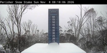
The abrupt cold snap, driven by a powerful atmospheric disturbance funneling polar air directly from the Antarctic landmass, delivered significant snowfall to iconic high-altitude regions. Major ski destinations including Thredbo, Perisher Valley, and Mount Hotham all registered substantial snow accumulations throughout Saturday and Sunday. Further south, the dramatic peak of Kunanyi/Mount Wellington overlooking Hobart was similarly capped in white, while severe localized storm activity blanketed urban and coastal environments elsewhere, leaving sporting ovals like Kingston Beach Oval in Tasmania covered in heavy layers of hail.
A Meteorological Phenomenon: Context and Chronology
While snow in November inevitably catches the public imagination and sparks widespread social media commentary, meteorologists from the Bureau of Meteorology (BoM) note that the event, though rare, is not entirely unprecedented. Similar unseasonal cold fronts have brushed southeastern Australia in past late-spring cycles, with notable comparable snowfalls occurring as recently as November 2022.

The meteorological sequence began late last week as a deep low-pressure system drew frigid air masses northward from the Southern Ocean. By Saturday morning, temperatures plummeted drastically below seasonal averages. Strong, biting south-westerly winds accompanied the cold front, significantly compounding the wind chill factor. Consequently, apparent "feels like" temperatures at midday on Sunday hovered well below 13 degrees Celsius across major metropolitan centers including Adelaide, Melbourne, Hobart, Canberra, and Sydney.
In stark contrast, northern and western parts of the continent—including Brisbane, Perth, and Darwin—continued to experience warm, stable conditions with temperatures comfortably resting in the twenties and thirties. The stark dichotomy underscored the vast geographic reach and localized intensity of the Australian continent’s diverse climate zones during transitional seasonal periods.
Public Reaction and Social Media Phenomenon
The sudden transformation of the landscape elicited a mix of disbelief and delight among residents, tourists, and outdoor workers stationed in the alpine regions. Social media platforms quickly filled with visual evidence of the wintry blast.
Madeleine McVie, a retail manager working at the Thredbo alpine resort, captured the astonishment of many when she posted video footage on Saturday afternoon expressing her disbelief. “You will not believe this, it’s springtime in Australia, in November, and it’s snowing,” McVie told her online followers, emphasizing that the precipitation was substantial rather than a passing flurry. By Sunday morning, she shared additional footage of herself riding empty chairlifts enveloped in active snowfall—a stark visual juxtaposition to the usual hiking and mountain biking activities associated with late-spring alpine operations.
Simultaneously, sporting organizations in Tasmania shared striking images of community grounds smothered in hail following severe localized storm cells. The Kingston Crows cricket club published photographs of the Kingston Beach Oval entirely disguised under a thick white blanket of frozen precipitation, illustrating the severe localized impact of the passing weather front.
Rapid Transition to Spring Warmth and Storms
Despite the dramatic weekend conditions, meteorological models indicate that the wintery respite will dissolve rapidly. Tristan Sumarna, a meteorologist at the Bureau of Meteorology, explained that the cold air mass is tracking eastward and losing intensity.
According to BoM forecasts, the lower-than-average temperatures are expected to clear by Tuesday, making way for a swift and pronounced warming trend. By the conclusion of the week, maximum temperatures in parts of Sydney are projected to climb into the mid-twenties, with some inland and western suburbs potentially touching the low thirties.
This thermal rebound, however, will not bring serene skies immediately. Sumarna noted that the influx of warm air colliding with residual atmospheric instability will inaugurate a classic "storm-like pattern" typical of dynamic springtime conditions in New South Wales. Meanwhile, neighboring states are experiencing more stable transitions; Tasmania and Victoria are anticipated to enjoy fine weather, with Melbourne reaching the low twenties and Hobart anticipating a pleasant top of 19 degrees Celsius by Monday afternoon.

Broader Climate Implications and Global Context
Climatologists and international bodies view this volatile swing between unseasonal cold snaps and rapid warming within the broader framework of accelerated global climate change and cyclical weather drivers. The Bureau of Meteorology, alongside international agencies including the United Nations, has repeatedly issued warnings regarding the development and intensification of a robust El Niño climate pattern.
Experts have characterized the ongoing global climate shifts as a force supercharging extreme weather events worldwide. The convergence of historical greenhouse gas emissions from fossil fuel consumption with strengthening natural climatic cycles is exacerbating temperature anomalies across both hemispheres. For Australia, a dominant El Niño phase traditionally correlates with significantly hotter and drier conditions throughout the southern hemisphere summer.
This macro-climate outlook suggests that the weekend’s cold snap may well be among the final winter-style flurries experienced by the region for many months. As the continent pivots firmly toward the warmer months, authorities and emergency services remain on high alert for the cascading effects of a hotter, drier summer. These risks include an elevated threat of severe bushfires, prolonged agricultural droughts, and increased strain on water resources across southern Africa and Australia alike—underscoring that while a November snowfall offers a brief and picturesque novelty, the underlying trajectory of regional weather points toward increasingly severe and volatile climate extremes.