
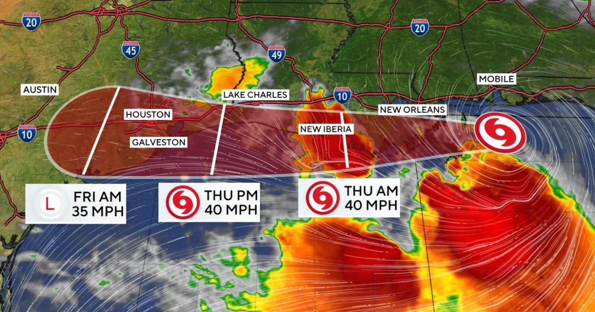
Tropical Storm Bertha, the second named storm of the 2026 Atlantic hurricane season, presented an unusual and challenging forecast for Gulf Coast residents this week, making an initial landfall in Louisiana on Wednesday before heading back offshore and setting its sights on a second projected landfall along the northwestern Gulf Coast of Texas on Thursday. This complex trajectory, characterized by its westward track and a brief re-emergence over open waters, kept emergency management officials and coastal communities on high alert as the system continued to deliver significant rainfall and tropical storm-force winds across a broad swath of the northern Gulf. The storm’s path, marked by a critical shift in direction towards the Lone Star State, underscored the unpredictable nature of tropical systems and the persistent threats they pose to the region’s densely populated coastal areas and vital infrastructure.
A Shifting Trajectory: Bertha’s Journey Across the Gulf
Bertha’s genesis traced back to a persistent tropical wave that organized rapidly in the warm waters of the Gulf of Mexico earlier in the week. By Tuesday night, it had strengthened into a tropical storm, boasting maximum sustained winds of 45 mph. However, its intensity began a gradual decrease, a trend closely monitored by meteorologists at the National Hurricane Center (NHC) in Miami. The storm’s initial interaction with land occurred on Wednesday, when it made its first landfall over a section of the Louisiana coast. This initial impact, while bringing tropical storm conditions, was relatively brief, as Bertha quickly re-emerged into the Gulf waters, confounding some earlier predictions that anticipated a more direct inland track after its Louisiana passage.
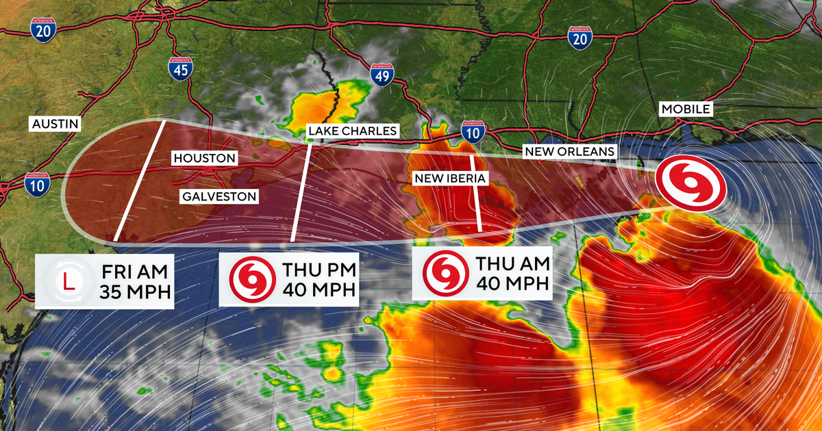
Early Thursday, the storm’s true intent became clearer as it began a distinct westward turn. Moving at a forward speed of 13 mph, Bertha traversed the waters off the Louisiana coast, effectively setting a course for Texas. The NHC’s updated advisories indicated that this westward movement would culminate in a second landfall along the northwestern Gulf Coast of Texas later on Thursday. This double-landfall scenario, though not entirely unprecedented in hurricane history, is sufficiently rare to complicate emergency preparedness and public messaging, requiring communities to pivot their response strategies rapidly.
The forecast projected Bertha to maintain tropical storm intensity right up until it reached the upper Texas coast. After its anticipated second landfall, the system was expected to weaken considerably and dissipate inland over Texas by Thursday night or early Friday. This dissipation, while signaling the end of Bertha’s life as an organized tropical cyclone, did not diminish the immediate concerns regarding its lingering impacts, particularly heavy rainfall and the potential for flash flooding far from the coastline.
Warnings and Preparations Blanket the Gulf Coast
In response to Bertha’s evolving threat, a Tropical Storm Warning was issued for a critical stretch of the Gulf Coast, extending from the Terrebonne/Lafourche Parish line in Louisiana westward to Sargent, Texas. This warning area encompassed a diverse range of communities, from vital port cities to smaller fishing villages and energy sector hubs, all bracing for the arrival of tropical storm conditions, including gusty winds, heavy rainfall, and elevated tides.
Emergency management agencies across both Louisiana and Texas activated their incident command systems, coordinating resources and disseminating crucial information to residents. In Louisiana, parishes that had experienced Bertha’s initial brush were tasked with assessing minor damages while simultaneously monitoring the storm’s continued westward movement, prepared to offer assistance to their Texan neighbors if needed. Louisiana state climatologist Jay Grymes had initially expressed cautious optimism, suggesting that the storm might be an "in-and-out kind of situation" for the state, with expectations of "some pockets of flooding." While this assessment largely held true for Louisiana’s initial encounter, the storm’s subsequent re-entry into the Gulf meant its broader impact was still unfolding.
On the Texas side, counties within the warning area initiated emergency protocols. Coastal communities like Galveston, Brazoria, Matagorda, and Harris County (home to Houston) were particularly vigilant. Local officials urged residents to finalize their storm preparations, secure outdoor items, and have emergency kits ready. Voluntary evacuation orders were considered for low-lying areas prone to storm surge flooding, though widespread mandatory evacuations were not immediately deemed necessary given Bertha’s moderate intensity. The Texas Department of Emergency Management (TDEM) coordinated with county officials, ensuring resources like high-water rescue vehicles and personnel were strategically positioned. Utility companies, including CenterPoint Energy and Entergy Texas, placed crews on standby, ready to respond to potential power outages caused by wind damage or flooding.
Understanding the Multifaceted Threat: Rainfall, Flooding, and Storm Surge
While Bertha’s maximum sustained winds of 45 mph positioned it at the lower end of tropical storm intensity, the primary concern for both Louisiana and Texas was the significant rainfall it was expected to deliver. The NHC cautioned that Bertha was anticipated to produce total rainfall amounts of 2 to 4 inches, with isolated totals potentially reaching 6 inches, particularly along the Texas Gulf Coast and South Texas through Thursday night.
This volume of rainfall, especially over already saturated ground or in urban areas with extensive impervious surfaces, presented a substantial risk of flash flooding. Major metropolitan areas like Houston, which has a well-documented history of severe flood events from tropical systems, were particularly vulnerable. Even moderate rainfall can quickly overwhelm drainage systems, leading to flooded streets, underpasses, and even residential areas. The NHC explicitly warned that "This rainfall may produce isolated flash flooding, especially in urban areas," prompting local authorities to advise motorists to avoid driving through flooded roads, reiterating the often-fatal "Turn Around, Don’t Drown" message.
Beyond the immediate rainfall, Bertha also carried the threat of storm surge. While not a major hurricane, the continuous onshore flow generated by the storm was forecast to raise water levels by up to 3 feet above normal tide levels in some locations along the coast. For low-lying coastal communities, even a few feet of storm surge can inundate roads, homes, and businesses, causing significant damage and posing a threat to life. Barrier islands and coastal wetlands, crucial for storm protection, were expected to experience elevated water levels, potentially leading to coastal erosion. The combination of storm surge and heavy rainfall could also exacerbate inland flooding by impeding the runoff of rainwater into the Gulf.
The 2026 Atlantic Hurricane Season: An Early and Active Start
Tropical Storm Bertha’s arrival marked the second named storm of the 2026 Atlantic hurricane season, signaling what forecasters at the National Oceanic and Atmospheric Administration (NOAA) had predicted to be an active period. Just weeks prior, Tropical Storm Arthur, the season’s first named storm, had also made landfall along the Gulf Coast of Texas in June, demonstrating an early and concerning pattern of tropical activity in the region.
NOAA’s pre-season outlook for 2026 had called for an above-average hurricane season, citing several contributing factors. These included warmer-than-average sea surface temperatures across the tropical Atlantic Ocean and Caribbean Sea, which provide more fuel for storm development and intensification. Additionally, the prevailing atmospheric conditions, including a potential La Niña phase in the Pacific, typically lead to reduced wind shear in the Atlantic basin, creating an environment more conducive to tropical cyclone formation and sustained strength. The rapid succession of Arthur and Bertha making landfalls on the Gulf Coast underscored the accuracy of these early season predictions and reinforced the need for heightened preparedness throughout the entirety of the hurricane season, which officially runs from June 1 to November 30.
The early activity served as a critical reminder for coastal residents to not become complacent. The Gulf Coast, with its extensive coastline, significant energy infrastructure, and vibrant tourism and fishing industries, is particularly vulnerable to tropical systems. The fact that both early storms affected the same general region within a short timeframe raised concerns about cumulative impacts, including prolonged power outages, disruptions to maritime activities, and the potential for widespread agricultural losses.
Broader Implications: Economic, Environmental, and Infrastructural Concerns
The repeated threat of tropical storms to the Gulf Coast carries significant economic, environmental, and infrastructural implications. The region is home to a substantial portion of the United States’ oil and natural gas production, with numerous offshore platforms and coastal refineries. While Bertha was not a major hurricane, its path and associated weather conditions prompted precautionary measures, including the temporary evacuation of non-essential personnel from some offshore platforms and potential disruptions to shipping lanes. Such disruptions, even minor ones, can have ripple effects on energy markets.
The Gulf Coast’s fishing industry, a cornerstone of its economy and culture, also faces challenges. Storms can damage fishing fleets, disrupt fishing grounds, and impact marine ecosystems, leading to economic losses for fishermen and related businesses. Similarly, the agricultural sector in Texas and Louisiana, which includes crops like rice, cotton, and sugarcane, can suffer significant losses from heavy rainfall, wind damage, and flooding.
Environmentally, tropical storms contribute to coastal erosion, especially in areas with vulnerable barrier islands and rapidly diminishing wetlands. The influx of freshwater from heavy rainfall can also alter salinity levels in estuaries, affecting marine life, while runoff can carry pollutants into delicate coastal ecosystems. The cumulative effects of multiple storms over a season can accelerate these environmental degradation processes.
From an infrastructural standpoint, repeated storm impacts test the resilience of coastal communities. Roads, bridges, power grids, and water treatment facilities are all vulnerable. While Bertha was not expected to cause catastrophic damage, the ongoing need for repairs and upgrades to withstand increasingly frequent and intense weather events places a considerable strain on local and state budgets. The experience of Bertha, following closely on Arthur’s heels, served as another case study in the ongoing challenge of building and maintaining resilient infrastructure in a changing climate.
Looking Ahead: Continued Vigilance and Long-Term Preparedness
As Tropical Storm Bertha was forecast to dissipate inland over Texas, the immediate threat of its winds and surge would recede. However, the legacy of its heavy rainfall would persist, with potential for localized flooding to continue into Friday and beyond as water slowly receded. Residents in affected areas were urged to remain vigilant, heed local advisories, and be aware of lingering hazards such as flooded roads, downed power lines, and potential structural damage.
The 2026 Atlantic hurricane season, still in its early stages, has already demonstrated its potential for activity and unpredictability. The lessons learned from Arthur and Bertha — the importance of early preparation, accurate forecasting, rapid dissemination of information, and robust emergency response — will be crucial as the season progresses into its typically more active peak months of August, September, and October. Coastal communities and emergency planners across the Gulf of Mexico and the wider Atlantic basin will continue to monitor weather patterns closely, understanding that each storm, regardless of its initial intensity, carries the potential for significant impact and demands a comprehensive and coordinated response. The saga of Tropical Storm Bertha underscores the dynamic nature of tropical weather and the perpetual need for preparedness in a vulnerable region.
